7 June 2013
UK engineer Atkins has teamed up with another company to offer a mapping service that captures 3D data on entire metropolitan areas.
Atkins says the “earthmine” technology creates 3D panoramic street-level imagery, providing accurate and detailed information about a built up area at relatively low cost, saving time an money for engineering projects.
“earthmine raises the bar of Atkins’ geospatial offering, and provides our clients a better way of visualising, understanding and planning their areas of interest, projects or sites,” said Cory Hope, mapping portfolio manager, Atkins.
After trialling the technology in UK cities and along lengths of motorway, Atkins has become a ‘value added reseller’ for earthmine.
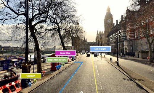
Atkins says its imaging system provides a data point for every pixel in every image. (Credit: Atkins)
If you’re wondering what earthmine does that Google Streetview doesn’t. For one thing, earthmine uses the same wide-angle stereo imaging technology as the Mars Exploration Rovers.
For another, Atkins says its imaging system provides a data point for every pixel in every image, enabling users to take measurements between any two points to get real-world position, length, width, and height information, or string together multiple points for perimeter and area calculations.
It allows the processing and digitising of assets in existing GIS tools within a matter of weeks.
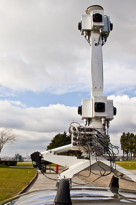
Earthmine uses the same wide-angle stereo imaging technology as the Mars Exploration Rovers. (Credit: Atkins)
Atkins says the images can be tagged with links to documentation for background information and used for measuring the position and dimensions and areas of objects such as signs and buildings, leading to the near complete digitisation of assets.
earthmine can also be integrated with software such as ESRI ArcGIS and AutoCAD Map3D, and accessed through a flash application or smart phone.
“By adding earthmine to our current mapping technologies, which include LiDAR and aerial surveys, and combining it with Atkins’ wider geospatial skills, we are offering our clients the most innovative and cost effective technologies on the market,” Cory Hope said.