7 May 2014
Road-builders in the UK are using an unmanned flying drone as a surveying tool to capture detailed images of the construction path.
The 350-sq-mm remote-controlled device is like a helicopter with four rotors, and is fitted with a video camera.
The trial is thought to be the first use of a drone in the road-building sector and was initiated to test the system’s capabilities and to help one of the team’s surveyors pass the test needed to receive a licence to operate the vehicle.
The project is in Northern Ireland, where a joint venture (JV) of contractors led by UK-based Costain is widening a 14.5km stretch of road between Belfast and Larne.
“Using a real aircraft there are limitations on how low it can fly, and weather can reduce visibility, whereas using a drone you can hover and get in close to structures,” said JV deputy project manager John Lee. “The system records high-definition footage, from which stills can be taken.”
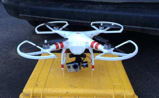
The 350-sq-mm remote-controlled device is like a helicopter with four rotors, and is fitted with a video camera (Costain)
The JV was previously using a proper plane for aerial photography, but the drone costs just a fraction of hiring a manned aircraft, and the licence required to operate it is also cheaper than a pilot’s licence.
Apart from surveying, the drone came in useful following a road traffic accident on the A8 in December when it was flown in to record the incident scene and examine how local traffic management was set up.
Costain’s group innovation and knowledge manager Tim Embley is impressed.
“From the highways sector point of view we would like to look at further applications and possibly get some people trained up,” he said. “I think there are definitely applications within the company that we could use it for.”